
Page 2 of rand mcnally laminated wall maps
(444 items found)
Filter by:
Delivery
All
1-2 day
Next day
Sort by:
Best match
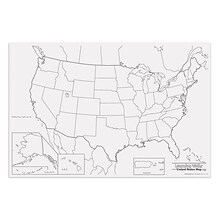
Pacon® Corporation® Learning Walls® US Map (PAC78760)
Item #: 901-JV38297
Subject: Social studies
Subject: Science/technology, nonfiction
Dimensions: 48" x 72"


National Geographic National Parks of the United States Map, Laminated, 42" x 30" (NGMRE01020602)
Item #: 901-24611394
Expertly researched and designed, National Geographic's wall map of National Parks of the United States highlights the nearly 400 magnificent parks across America.
Measures 42" x 30"
The country is represented in subtle earth-tones with shaded mountain relief and intricately drawn river systems.
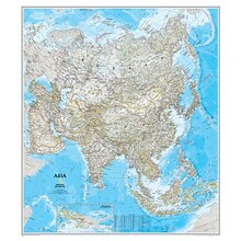
National Geographic Maps® Asia Classic, Laminated
Item #: 901-JV62401
Subject: Social studies
Subject: Science/technology, nonfiction
Dimensions: 34" x 38"

National Geographic Antarctica Satellite Map, Laminated, 31.25" x 20.25" (NGMRE00620144)
Item #: 901-24611405
National Geographic Antarctica Satellite Wall Map has a striking view of Antarctica's terrain, compiled from 4,500 satellite scans
Additional inset maps show surface elevation, ice sheet thickness, velocity of ice flow, and sea ice movement and windflow.
The map is encapsulated in heavy-duty 1.6 mil laminate which makes the paper much more durable and resistant to the swelling and shrinking caused by changes in humidity.


National Geographic United States for Kids Map, Laminated, 24" x 36" (NGMRE01021159)
Item #: 901-24611434
Expertly researched and designed, National Geographic's The United States for Kids wall map is an enticing and engaging United States map perfect for classroom, home or library.
Measures 24" x 36"
Recommended by geography educators for ages 7–12, this map features an optimized map design for readability and easy, intuitive learning.


National Geographic World Physical Map, Laminated, 45.75" x 30.5" (NGMRE00620132)
Item #: 901-24611413
Expertly researched and designed, National Geographic's The Physical World map highlights the Earth's land and undersea forms with exquisite hand-painted relief.
Two corner inset maps show the Earth's crust and world climatic zones.
Drawn in the Winkel Tripel projection, distortions are minimized and unlike many other World maps, Greenland is show the same size as Argentina and not as the size of all of South America.

National Geographic Australia Classic Map, Laminated, 30.25" x 27" (NGMRE00620146)
Item #: 901-24611407
Expertly researched and designed, National Geographic's Australia Wall Map is the authoritative map of Asia by which other reference maps are measured.
Signature Classic style map with bright, easy to read color palette with blue oceans and colorful borders
Clearly defined international boundaries, cities, islands, airports, and physical features


National Geographic The World for Kids Map, Laminated, 36" x 24" (NGMRE01020772)
Item #: 901-24611323
Expertly researched and designed, National Geographic's The World for Kids wall map is an enticing and engaging world map perfect for classroom, home or library.
Measures 36" x 24"
Recommended by geography educators for ages 7–12, this map features an optimized map design for readability and easy, intuitive learning.


National Geographic World Executive Map, Mural, 110" x 76.5" (NGMRE00620092)
Item #: 901-24611398
National Geographic World Wall Map Executive is expertly researched and designed, National Geographic's World Wall Map is the authoritative map of the world by which other reference maps are measured.
Antique-style "executive" color palette
Thousands of place names carefully and artfully placed to maintain legibility in heavily populated areas
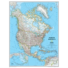
National Geographic Maps North America Wall Map, 24" x 30"
Item #: 901-JV158524
Subject: Social studies
Subject: Science/technology, nonfiction
Dimensions: 24" x 30"


National Geographic World and United States for Kids, Poster Size, Map Pack Bundle, 36" x 24" (NGMRE01021233B)
Item #: 901-24611447
National Geographic's The World for Kids and United State for Kids wall maps are enticing and engaging world and United States maps perfect for classroom, home or library.
Measures 36" x 24"
Recommended by geography educators for ages 7–12, these maps feature an optimized map design for readability and easy, intuitive learning.
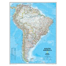
National Geographic Maps South America Wall Map, 24" x 30"
Item #: 901-JV158528
Subject: Social studies
Subject: Science/technology, nonfiction
Classic map of South America shows political boundaries, place-names, airports, major roads and highways, and other geographic features for the entire continent


National Geographic World and United States Classic, Poster Size, Map Pack Bundle, 36" x 24" (NGMRE01021231B)
Item #: 901-24611427
National Geographic's World and United States maps are the standard by which all other reference maps are measured.
Measures 36" x 24"
The signature Classic style maps use a bright, easy to read color palette featuring blue oceans and stunning shaded relief that has been featured on National Geographic wall maps for over 75 years.


National Geographic World and United States Executive, Poster Size, Map Pack Bundle, 36" x 24" (NGMRE01021232B)
Item #: 901-24611443
National Geographic's World and United States maps are the standard by which all other reference maps are measured.
Measures 36" x 24"
Antique-style "executive" color palette
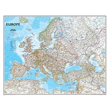
National Geographic Maps Europe Wall Map, 30" x 24"
Item #: 901-JV158525
Subject: Social studies
Subject: Science/technology, nonfiction
Dimensions: 30" x 24"
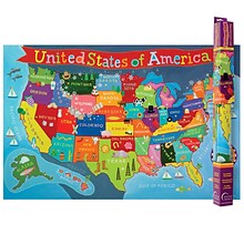
Round World Products United States Map for Kids, 24" x 36" (RWPKM02)
Item #: 901-JV66748
Kids U.S.A Map
Size(s): 24" x 36"
Material(s): Laminated Paper


National Geographic Earth's Moon Map, Laminated, 42.5" x 28.5" (NGMRE00620137)
Item #: 901-24611437
National Geographic's "The Earth's Moon" is like having an atlas and almanac in one.
This incredibly informative wall map features detailed depictions of the entire surface of the moon with a selective index showing the named physical features.
Diagrams show the moon's orbital paths, rotation around Earth, librations, how solar and lunar eclipses occur, how the moon affects Earth's tides, and more.


National Geographic World and United States Coloring, Map Pack Bundle, 36" x 24" (NGMRE01021221B)
Item #: 901-24611425
National Geographic's cartographers adapted our World and United States for Kids Maps to black and white outline versions that you can color.
Measures 36" x 24"
The World and United States Coloring Maps include country and state flags that can all be colored along with a bonus full color letter size sheets that has all of the flags.

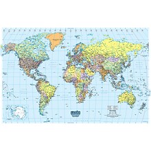
House of Doolittle Laminated World Map, 50" x 33" (HOD710)
Item #: 901-JV158533
Laminated Classroom World Map
Size: 33"(H) x 50"(W)
Material(s): Recycled Paper/Polyethylene


National Geographic The Heavens Map, Laminated, 30.5" x 22.75" (NGMRE00620136)
Item #: 901-24611415
National Geographic's The Heavens shows star charts and constellations for both the Northern and Southern Hemispheres.
All 2,844 of the stars on the chart, plus nebulae and star clusters, can be seen with the unaided eye, making this chart a perfect companion for viewing the night sky.
They inspire great works of art, and tempt our imaginations into creating stories and myths from the shapes we see.
House of Doolittle Laminated World Map, 38" x 25" (HOD711)
Item #: 901-JV158531
Classroom World and U.S.A Map
Size: 25"(H) x 38"(W)
Material(s): Recycled Paper/Polyethylene
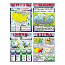
McDonald Publishing, Basic Map Skills Teaching Poster Set 22" x 17.5", 9/set (MC-P222)
Item #: 901-JV23998989
Map Skills
22" x 17.5"
Age 9-14
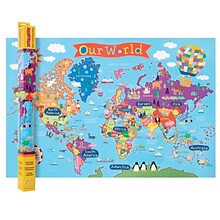
Round World Products, World Map for Kids, 24" x 36" (RWPKM01)
Item #: 901-24062999
Kids world map
24" x 36"
Laminated. Assorted colors


National Geographic The Dynamic Earth, Plate Tectonics Map, Laminated, 36" x 24" (NGMRE01020634)
Item #: 901-24611386
National Geographic Dynamic Earth, Plate Tectonics Wall Map illustrates plate tectonics & features stunning bathymetry & naturally colored relief, as well as volcano and earthquake data through 2011.
Measures 36" x 24"
The Dynamic Earth map illustrates 17 major tectonic plates and highlights diffuse plate boundaries, convergent boundaries, spreading boundaries, fault zones, hot spots, and more.


