Page 3 of Maps & Globes
(113 Products)
Sort by:
Best match
Hemispheres Blue Ocean Series World & USA Laminated Wall Maps, 2-Pack (RWPHMB02PK)
Item #: 901-JV1112500
Classroom U.S.A & World Map
Size(s): 38" x 51" World, 38" x 48" USA
Material(s): Laminated Paper


National Geographic United States Executive Map, Poster Size and Laminated, 36" x 24" (NGMRE01020388)
Item #: 901-24611390
National Geographic's United States wall map is the standard by which other reference maps of the U.S. are measured.
The 36" x 24" poster size supports easy and affordable framing and mounting, and takes less wall space than standard wall maps.
Antique-style "executive" color palette


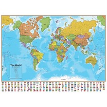
National Geographic World and United States Classic, Poster Size, Map Pack Bundle, 36" x 24" (NGMRE01021231B)
Item #: 901-24611427
National Geographic's World and United States maps are the standard by which all other reference maps are measured.
Measures 36" x 24"
The signature Classic style maps use a bright, easy to read color palette featuring blue oceans and stunning shaded relief that has been featured on National Geographic wall maps for over 75 years.


National Geographic World Executive Map, Poster Size and Laminated, 36" x 24" (NGMRE01020376)
Item #: 901-24611378
Expertly researched and designed, National Geographic's World Wall Map is the authoritative map of the world by which other reference maps are measured.
The 36" x 24" poster size supports easy and affordable framing and mounting, and takes less wall space than standard wall maps.
Antique-style "executive" color palette
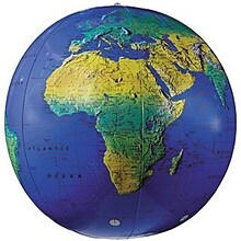
Replogle Globes Inflatable Topographical Globe, 12"(Dia), 2 Ea
Item #: 901-932907
Age group and grade: Ages all and grades all
Subject: Social studies
Globe features: Physical map styling, inflatable


National Geographic Space, Stargazer folded Map Pack Bundle, Folded: 4.25" x 9.25" ; Flat: 25.25" x 18.5" (NGMRE01021309B)
Item #: 901-24611454
National Geographic's Stargazer Map and Guides Map Pack Bundle of Space includes maps that get progressively further from Earth on four waterproof tear-resistant maps.
Measures 4.25" x 9.25" folded and 25.25" x 18.5" flat
Each Stargazer Map and Guide shows detailed maps and graphics to help locate features on the moon, planets, and stars.

Learning Resources Inflatable Globe, Labeling
Item #: 901-JV35588
Age group and grade: Ages 5 - 8 and grades kindergarten+
Large 27" inflatable globe printed with only the continents and lines of latitude and longitude
Size: 27"(Dia)


National Geographic Continental Divide Trail Map, In Gift Box, 18" x 48" (NGMRE01021204X)
Item #: 901-24611457
National Geographic Continental Divide Trail Wall Map- National Geographic's map of the Continental Divide Trail is ideal for fans and hikers of this magnificent National Scenic Trail.
Measures 18" x 48"
It makes a great planning tool or as reference to track progress on the 3,100 plus mile length.


National Geographic World Classic Map, Enlarged and Laminated, 69.25" x 48" (NGMRE00622003)
Item #: 901-24611409
Expertly researched and designed, National Geographic's World Wall Map is the authoritative map of the world by which other reference maps are measured.
Measures 69.25" x 48"
Signature Classic style map with bright, easy to read color palette with blue oceans and colorful borders
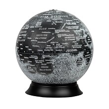
National Geographic Illuminated Moon Globe, 12" Diameter (RE-83522)
Item #: 901-24439128
Illuminated Moon Globe
Globe Size: 12" Diameter
Material: Vinyl, Plastic


National Geographic The Dynamic Earth, Plate Tectonics Map, Laminated, 36" x 24" (NGMRE01020634)
Item #: 901-24611386
National Geographic Dynamic Earth, Plate Tectonics Wall Map illustrates plate tectonics & features stunning bathymetry & naturally colored relief, as well as volcano and earthquake data through 2011.
Measures 36" x 24"
The Dynamic Earth map illustrates 17 major tectonic plates and highlights diffuse plate boundaries, convergent boundaries, spreading boundaries, fault zones, hot spots, and more.
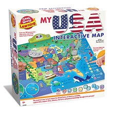
Small World Toys My USA Interactive Map, 30.7" x 24" (SWT9721053)
Item #: 901-24519539
Great learning and educational toy
Interactive talking map
Great way for children to learn the USA map while playing

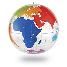
Waypoint Geographic 4" Diameter Blue Ocean GyroGlobe, Pack of 2 (RWPWP50200-2)
Item #: 901-24515200
4" Compact mini globe
Features swivel and tilt multi-directional motion allowing the globe to easily rotate in all directions
Distinguished by it's multi-color styling which makes learning about and identifying locations easy!
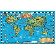
Popar 32" x 54" Kid's World Map Interactive Wall Chart with Free App (RWPWC04)
Item #: 901-24526317
Read-alongs and videos about the ancient world, modern world, and natural wonders
Measures 32" x 54"
Interactive with free app


National Geographic United States Decorator Map, Enlarged and Laminated, 43.5" x 30.5" (NGMRE00622084)
Item #: 901-24611365
National Geographic's Decorator style map of the United States features rich, attractive color fills that bring any room or classroom to life.
Measures 43.5" x 30.5"
Colorful Decorator style map with vibrant color palette that fills each country for easy identification
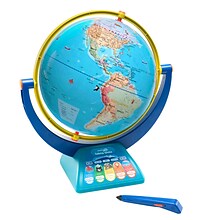

Educational Insights GeoSafari Jr. Talking Globe
Item #: 901-24366639
Travel the globe and discover the fascinating world of geography, animals, and nature
12” Globe featuring dual-swivel action and smart stylus pen with built-in speaker
Over 1,000 facts about animals and nature, countries and cities, continents and oceans


National Geographic Bird Migration, Western Hemisphere Map, Laminated, 20.25" x 31.25" (NGMRE01020306)
Item #: 901-24611385
National Geographic Bird Migration, Western Hemisphere Wall Map shows the mystery of bird migration and the incredible journeys that birds undertake in the Americas each year.
Measures 20.25" x 31.25"
67 types of birds that migrate are shown on a map of the Americas that is overlaid with pathways that show migration routes from nesting grounds to wintering areas.
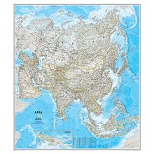
National Geographic Maps® Asia Classic, Laminated
Item #: 901-JV62401
Subject: Social studies
Subject: Science/technology, nonfiction
Dimensions: 34" x 38"


National Geographic World Classic Map, Laminated, 43.5" x 30.5" (NGMRE00622002)
Item #: 901-24611430
Expertly researched and designed, National Geographic's World Wall Map is the authoritative map of the world by which other reference maps are measured.
Measures 43.5" x 30.5"
Signature Classic style map with bright, easy to read color palette with blue oceans and colorful borders


National Geographic World and United States Coloring, Map Pack Bundle, 36" x 24" (NGMRE01021221B)
Item #: 901-24611425
National Geographic's cartographers adapted our World and United States for Kids Maps to black and white outline versions that you can color.
Measures 36" x 24"
The World and United States Coloring Maps include country and state flags that can all be colored along with a bonus full color letter size sheets that has all of the flags.


Waypoint Geographic World/USA Laminated Notebook Maps, 12/Pack (RWPNB02)
Item #: 901-24610186
Makes easy reference for continents, countries, states and major World and USA cities and other points of interest. Laminated
World on one side, USA on the other
Set includes 12 notebook maps measuring 8.5" x 11" and a 12 count clip strip


National Geographic World Executive Map, Enlarged and Laminated, 73" x 48" (NGMRE00622088)
Item #: 901-24611311
Expertly researched and designed, National Geographic's World Wall Map is the authoritative map of the world by which other reference maps are measured.
Measures 73" x 48"
Antique-style "executive" color palette


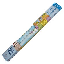
National Geographic The Milky Way Map, Laminated, 31.25" x 20.25" (NGMRE00620140)
Item #: 901-24611410
This computer-generated image of the Milky Way shows the entire galaxy in one perspective of a 3-D model compiled specially for National Geographic.
The model incorporates the positions of hundreds of thousands of stars and nebulae within the galaxy, shows Earth's location.
Includes additional photographs, descriptions and locations of fascinating phenomena throughout the Milky Way.


National Geographic Night Sky, Stargazer folded Map Pack Bundle, Folded: 4.25" x 9.25" ; Flat: 25.25" x 18.5" (NGMRE01021310B)
Item #: 901-24611374
National Geographic's The Night Sky - Stargazer Map Pack the Northern Hemisphere is centered on Polaris, the North Star, the Southern Hemisphere is centered near Crux, the Southern Cross.
Measures 4.25" x 9.25" folded and 25.25" x 18.5" flat
As the Earth moves in its orbit around the Sun the constellations in the sky change. The Night Sky maps include four seasonal charts that are specific for each season.

