Page 4 of Maps & Globes
(113 Products)
Sort by:
Best match


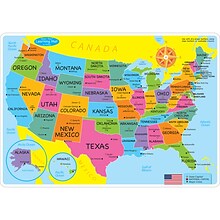
National Geographic United States for Kids Map, Laminated, 24" x 36" (NGMRE01021159)
Item #: 901-24611434
Expertly researched and designed, National Geographic's The United States for Kids wall map is an enticing and engaging United States map perfect for classroom, home or library.
Measures 24" x 36"
Recommended by geography educators for ages 7–12, this map features an optimized map design for readability and easy, intuitive learning.


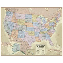
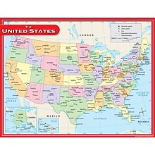
National Geographic United States Classic Map, Enlarged and Laminated, 69.25" x 48" (NGMRE00602987)
Item #: 901-24611392
National Geographic's United States wall map is the standard by which other reference maps of the U.S. are measured
Signature Classic styling with bright, easy to read color palette with blue water and colorful state borders. All 50 states with insets for Hawaiian Islands and Alaska
Enlarged maps provide an immersive experience in any home or office environment. The exceptional cartography is even easier to appreciate at the larger size


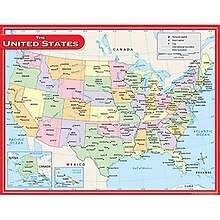
National Geographic United States Decorator Map, Enlarged and Laminated, 43.5" x 30.5" (NGMRE00622084)
Item #: 901-24611365
National Geographic's Decorator style map of the United States features rich, attractive color fills that bring any room or classroom to life.
Measures 43.5" x 30.5"
Colorful Decorator style map with vibrant color palette that fills each country for easy identification
Hemispheres® Boardroom Series United States Laminated Wall Map, 38" x 48" (RWPHM04)
Item #: 901-24519761
Modern antique decorative style
Up-to-date cartography and points of interest
Includes states, capitals and more


National Geographic The Dynamic Earth, Plate Tectonics Map, Laminated, 36" x 24" (NGMRE01020634)
Item #: 901-24611386
National Geographic Dynamic Earth, Plate Tectonics Wall Map illustrates plate tectonics & features stunning bathymetry & naturally colored relief, as well as volcano and earthquake data through 2011.
Measures 36" x 24"
The Dynamic Earth map illustrates 17 major tectonic plates and highlights diffuse plate boundaries, convergent boundaries, spreading boundaries, fault zones, hot spots, and more.


National Geographic Continental Divide Trail Map, In Gift Box, 18" x 48" (NGMRE01021204X)
Item #: 901-24611457
National Geographic Continental Divide Trail Wall Map- National Geographic's map of the Continental Divide Trail is ideal for fans and hikers of this magnificent National Scenic Trail.
Measures 18" x 48"
It makes a great planning tool or as reference to track progress on the 3,100 plus mile length.
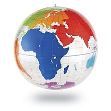

Learning Resources Inflatable Globe, Labeling
Item #: 901-JV35588
Age group and grade: Ages 5 - 8 and grades kindergarten+
Large 27" inflatable globe printed with only the continents and lines of latitude and longitude
Size: 27"(Dia)


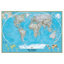
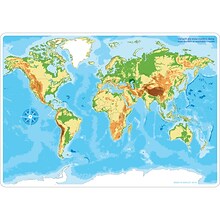
National Geographic World Classic Map, Laminated, 43.5" x 30.5" (NGMRE00622002)
Item #: 901-24611430
Expertly researched and designed, National Geographic's World Wall Map is the authoritative map of the world by which other reference maps are measured.
Measures 43.5" x 30.5"
Signature Classic style map with bright, easy to read color palette with blue oceans and colorful borders
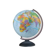
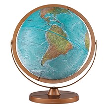
Replogle Traveler World Globe, 12"Dia (30513)
Item #: 901-JV38113
World globe is a great tool for high school and college students
Globe dimensions: 12"Dia, 16"H x 13"W x 12"D
Ball made of 100% reclaimed paper fiber in blue with smoke black plastic base


National Geographic World Classic Map, Enlarged and Laminated, 69.25" x 48" (NGMRE00622003)
Item #: 901-24611409
Expertly researched and designed, National Geographic's World Wall Map is the authoritative map of the world by which other reference maps are measured.
Measures 69.25" x 48"
Signature Classic style map with bright, easy to read color palette with blue oceans and colorful borders


National Geographic World and United States Classic, Poster Size, Map Pack Bundle, 36" x 24" (NGMRE01021231B)
Item #: 901-24611427
National Geographic's World and United States maps are the standard by which all other reference maps are measured.
Measures 36" x 24"
The signature Classic style maps use a bright, easy to read color palette featuring blue oceans and stunning shaded relief that has been featured on National Geographic wall maps for over 75 years.

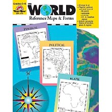
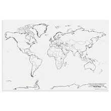
Evan-Moor® The World - Reference Maps & Forms
Item #: 901-JV37097
Age group and grade: Ages 3 - 18 and grades 3rd - 6th
Also includes evaluation forms, crossword puzzle, word search and answer key
Author: Jo Ellen Moore
National Geographic World Classic Wall Map, Mural, 110" x 76.5" (NGMRE00622007)
Item #: 901-JV62402
Mural World Map
Size(s): 110" x 76.5"
Material(s): Laminated Paper
Pacon® Corporation® Learning Walls® World Map (PAC78770)
Item #: 901-JV38298
Subject: Science/technology, nonfiction
Dimensions: 48" x 72"
A place for students and teachers to interact creatively
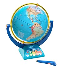
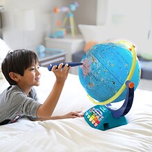
Educational Insights GeoSafari Jr. Talking Globe
Item #: 901-24366639
Travel the globe and discover the fascinating world of geography, animals, and nature
12” Globe featuring dual-swivel action and smart stylus pen with built-in speaker
Over 1,000 facts about animals and nature, countries and cities, continents and oceans

National Geographic Australia Classic Map, Laminated, 30.25" x 27" (NGMRE00620146)
Item #: 901-24611407
Expertly researched and designed, National Geographic's Australia Wall Map is the authoritative map of Asia by which other reference maps are measured.
Signature Classic style map with bright, easy to read color palette with blue oceans and colorful borders
Clearly defined international boundaries, cities, islands, airports, and physical features
Replogle Globes Atlantis Globe, 12" (RE-33801)
Item #: 901-JV38115
Map color: Blue
Base material: Plastic
Style: Traditional
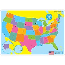
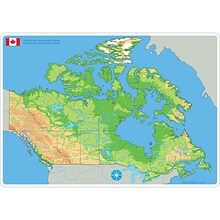
Ashley Productions Smart Poly 12" x 17" U.S. Basic Map Learning Mat, Double-Sided (ASH95000)
Item #: 901-24529551
Heavy duty double-sided surface, no lamination required
Use with dry erase or water based markers and washable crayons
Water Resistant
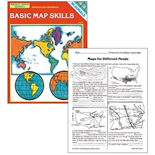
Basic Map Skills Reproducible Book, Grades 6–9
Item #: 901-JV44761
Age group and grade: Ages 9 - teens and grades 6th - 9th
Exercises focus on compass roses, latitude and longitude, time zones, landforms, types of maps and more
Author: Laurie Gilbert and Pat Biggs
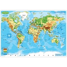
Ashley Productions Smart Poly 12" x 17" World Physical Map Learning Mat, Double-Sided (ASH95003)
Item #: 901-24529521
Heavy duty double-sided surface, no lamination required
Use with dry erase or water based markers and washable crayons
Water Resistant


National Geographic World Decorator Map, Laminated, 46" x 30.5" (NGMRE00622079)
Item #: 901-24611317
Expertly researched and designed, National Geographic's World Wall Map is the authoritative map of the world by which other reference maps are measured.
Measures 46" x 30.5"
Colorful Decorator style map with vibrant color palette that fills each country for easy identification
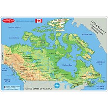
Ashley Productions Smart Poly 12" x 17" Physical Canada Map Learning Mat, Double-Sided (ASH95024)
Item #: 901-24529474
Heavy duty double-sided surface, no lamination required
Use with dry erase or water based markers and washable crayons
Water Resistant
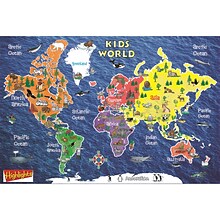
Replogle Kids World Peel & Stick Wall Map, 42" x 30" (RE-72161)
Item #: 901-24439043
Kids World Peel & Stick Wall Map
Map Size: 42" x 30"
Printed on Peel and Stick Repositionable Media
Teacher Created Resources US Map Chart, 17"W x 22"H, 10/Bundle (TCR7657)
Item #: 901-879555
Theme/design: Social studies
Color: Assorted
Size: 17"(H) x 22"(W)

