We're sorry, this item is no longer available Choose an alternative
Product details
Reviews
Brand
Pack Qty
Age
Age Range
Contents
Education Subject Matter
Environmental Design Features
Kids Theme
Learning Game Type
Length in Inches
Material of Item
Number of Pieces
Number of Puzzle Pieces
Puzzle Type
School Grade
True Color
Width in Inches
Item no longer available
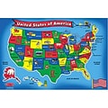
Item # 901-JV44016
Melissa & Doug
1
Youth
N/A
N/A
N/A
N/A
Other
N/A
24
Cardboard
51
1-100
Floor Puzzle
N/A
N/A
36
Shop Maps & Globes
(113 Products)
Sort by:
Best match
Waypoint Geographic 4" Diameter Blue Ocean GyroGlobe, Pack of 2 (RWPWP50200-2)
Item #: 901-24515200
4" Compact mini globe
Features swivel and tilt multi-directional motion allowing the globe to easily rotate in all directions
Distinguished by it's multi-color styling which makes learning about and identifying locations easy!
House of Doolittle Laminated World Map, 38" x 25" (HOD711)
Item #: 901-JV158531
Classroom World and U.S.A Map
Size: 25"(H) x 38"(W)
Material(s): Recycled Paper/Polyethylene
National Geographic World Executive Map, Enlarged and Laminated, 73" x 48" (NGMRE00622088)
Item #: 901-24611311
Expertly researched and designed, National Geographic's World Wall Map is the authoritative map of the world by which other reference maps are measured.
Measures 73" x 48"
Antique-style "executive" color palette
National Geographic World and United States Executive, Poster Size, Map Pack Bundle, 36" x 24" (NGMRE01021232B)
Item #: 901-24611443
National Geographic's World and United States maps are the standard by which all other reference maps are measured.
Measures 36" x 24"
Antique-style "executive" color palette
National Geographic World Executive Map, Poster Size and Laminated, 36" x 24" (NGMRE01020376)
Item #: 901-24611378
Expertly researched and designed, National Geographic's World Wall Map is the authoritative map of the world by which other reference maps are measured.
The 36" x 24" poster size supports easy and affordable framing and mounting, and takes less wall space than standard wall maps.
Antique-style "executive" color palette
Replogle Globes Inflatable Topographical Globe, 12"(Dia), 2 Ea
Item #: 901-932907
Age group and grade: Ages all and grades all
Subject: Social studies
Globe features: Physical map styling, inflatable
National Geographic National Parks & National Forest of the US, Map Pack Bundle (NGMDM01021301B)
Item #: 901-24611388
National Geographic's Destination Maps of National Forests and Grasslands of the United States highlights the 154 national forests and 20 national grasslands across America.
A list of all forest service and grasslands units, sorted by region, is also included to help you find the closest recreational opportunity.
The National Park and National Forest Map Pack Includes: National Parks of the United States & National Forests and Grasslands of the United States
National Geographic Earth's Moon Map, Laminated, 42.5" x 28.5" (NGMRE00620137)
Item #: 901-24611437
National Geographic's "The Earth's Moon" is like having an atlas and almanac in one.
This incredibly informative wall map features detailed depictions of the entire surface of the moon with a selective index showing the named physical features.
Diagrams show the moon's orbital paths, rotation around Earth, librations, how solar and lunar eclipses occur, how the moon affects Earth's tides, and more.
Small World Toys My USA Interactive Map, 30.7" x 24" (SWT9721053)
Item #: 901-24519539
Great learning and educational toy
Interactive talking map
Great way for children to learn the USA map while playing
Learning Resources Inflatable Globe, 12"
Item #: 901-JV34271
Age group and grade: Ages 5 - 13
Size: 12"(Dia)
Includes a repair kit and an activity guide
National Geographic The Americas Classic Map, Laminated (NGMRE00620152)
Item #: 901-24611431
Expertly researched and designed, National Geographic's The Americas Wall Map is the authoritative map of Europe by which other reference maps are measured.
Measures 23.75" x 36.5"
Signature Classic style map with bright, easy to read color palette with blue oceans and colorful borders
National Geographic Maps North America Wall Map, 24" x 30"
Item #: 901-JV158524
Subject: Social studies
Subject: Science/technology, nonfiction
Dimensions: 24" x 30"
National Geographic Maps South America Wall Map, 24" x 30"
Item #: 901-JV158528
Subject: Social studies
Subject: Science/technology, nonfiction
Classic map of South America shows political boundaries, place-names, airports, major roads and highways, and other geographic features for the entire continent
Advantus® 12" Political World Globe, Blue Oceans
Item #: 901-AVT30502
World globe
Each globe has a diameter of 12"
Globe with raised relief and a full swing meridian
National Geographic Australia Classic Map, Laminated, 30.25" x 27" (NGMRE00620146)
Item #: 901-24611407
Expertly researched and designed, National Geographic's Australia Wall Map is the authoritative map of Asia by which other reference maps are measured.
Signature Classic style map with bright, easy to read color palette with blue oceans and colorful borders
Clearly defined international boundaries, cities, islands, airports, and physical features
Replogle Globes Treasury Floor Model Globe, 12" (RE-30803)
Item #: 901-JV62863
Classroom World Globe
Size(s): 12" diameter
Material(s): Plastic, Wood, Metal
National Geographic United States Decorator Map, Enlarged and Laminated, 43.5" x 30.5" (NGMRE00622084)
Item #: 901-24611365
National Geographic's Decorator style map of the United States features rich, attractive color fills that bring any room or classroom to life.
Measures 43.5" x 30.5"
Colorful Decorator style map with vibrant color palette that fills each country for easy identification
Educational Insights GeoSafari Jr. Talking Globe
Item #: 901-24366639
Travel the globe and discover the fascinating world of geography, animals, and nature
12” Globe featuring dual-swivel action and smart stylus pen with built-in speaker
Over 1,000 facts about animals and nature, countries and cities, continents and oceans
National Geographic United States Classic Map, Poster Size and Laminated, 36" x 24" (NGMRE01020385)
Item #: 901-24611423
National Geographic United States Wall Map is expertly researched and designed, National Geographic's United States wall map is the standard by which other reference maps of the U.S. are measured.
The 36" x 24" poster size supports easy and affordable framing and mounting, and takes less wall space than standard wall maps.
Antique-style "executive" color palette
Replogle Globe Political Inflate-A-Globe, Light Blue, 12", 2/Bundle
Item #: 901-883184
Style: Political
Size: 12"(Dia)
Introduce children to geography with this inflatable globe, available in a variety of sizes and styles, each globe is brilliantly colored and extremely durable
National Geographic Pacific Crest Trail Map, In Gift Box, 18" x 48" (NGMRE01020758X)
Item #: 901-24611433
Expertly researched and designed, National Geographic's map of the Pacific Crest Trail is ideal for fans and hikers of this magnificent National Scenic Trail.
Measures 18" x 48"
It makes a great planning tool or as reference to track progress on the 2,600 plus mile length.
Replogle Globes The Franklin Globe 12", 1 Globe (RE-31501)
Item #: 901-JV2323238
Classroom World Globe
Size(s): 12" diameter
Material(s): Plastic
National Geographic The Dynamic Earth, Plate Tectonics Map, Laminated, 36" x 24" (NGMRE01020634)
Item #: 901-24611386
National Geographic Dynamic Earth, Plate Tectonics Wall Map illustrates plate tectonics & features stunning bathymetry & naturally colored relief, as well as volcano and earthquake data through 2011.
Measures 36" x 24"
The Dynamic Earth map illustrates 17 major tectonic plates and highlights diffuse plate boundaries, convergent boundaries, spreading boundaries, fault zones, hot spots, and more.
National Geographic National Parks of the United States Map, Laminated, 42" x 30" (NGMRE01020602)
Item #: 901-24611394
Expertly researched and designed, National Geographic's wall map of National Parks of the United States highlights the nearly 400 magnificent parks across America.
Measures 42" x 30"
The country is represented in subtle earth-tones with shaded mountain relief and intricately drawn river systems.
