


We're sorry, this item is no longer available Choose an alternative
Product details
Reviews
Age Maximum
Age Minimum
Age Range
Age Set
Brand
Education Subject Matter
Educational & STEM Toy Type
Made in America
Material of Item
Number of Educational & STEM Toys per Pack
Product Type
School Grade
Selling Quantity
Selling Quantity (UOM)
STEM Education
STEM.org Authenticated
Teaching Resource Type
True Color
Item no longer available

Item # 901-24493672
N/A
N/A
N/A
All Ages
Little Experimenter
N/A
N/A
N/A
N/A
N/A
N/A
N/A
N/A
N/A
N/A
N/A
N/A
N/A
N/A
N/A
Kids
N/A
Harcourt
Math
N/A
N/A
N/A
N/A
N/A
Multi-Grade
N/A
N/A
N/A
N/A
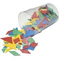
Counter
Multicolor
More alternatives

$37.99
bundle
N/A
N/A
N/A
Multi Age
Tornado Tube
Science
Science Lab Sets
Yes
Assorted Materials
N/A
N/A
Multi-Grade
1
Pack
Supports STEM Learning
N/A
N/A
Multicolor

N/A
N/A
N/A
Multi Age
Edx Education
Science
Building Sets
N/A
Assorted Materials
200
Construction
Multi-Grade
1
Each
Supports STEM Learning
N/A
N/A
Multicolor
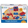
All Ages
8 Years
8+ Years
N/A
Learning Resources
Science
Other
N/A
Plastic
N/A
Simple Machines
Multi-Grade
N/A
Pack
STEM + Design Thinking
Yes
N/A
Multicolor
Shop Maps & Globes
(112 Products)
Sort by:
Best match


Item #:901-24611428
$27.99
Per each


Item #:901-24611392
$63.99
Per each


Item #:901-24611382
$37.79
Per each


Item #:901-24611374
$25.99
Per set


Item #:901-24611371
$24.29
Per each


Item #:901-24611431
$32.69
Per each


Item #:901-24611415
$24.29
Per each


Item #:901-24611430
$36.19
Per each


Item #:901-24611443
$30.99
Per set


Item #:901-24611317
$27.99
Per each

Item #:901-JV62863
5
(1)
$129.19
Per each

Item #:901-JV158524
2.4
(5)
$29.39
Per each


Item #:901-24611311
$63.99
Per each


Item #:901-24611366
$24.29
Per each


Item #:901-24611410
$24.29
Per each

Item #:901-24451753
$255.19
Per each

Item #:901-JV158533
4.5
(8)
$50.39
Per each


Item #:901-24611369
$36.79
Per each


Item #:901-24611413
$36.19
Per each


Item #:901-24611454
$36.99
Per set


Item #:901-24611398
$147.19
Per each


