Page 7 of universal map group u s world maps
(444 items found)
Sort by:
Best match

Photo Image Laser Postcards, Protect Your Smile
Item #: 901-660100
Occasion: Preventive
MAP® Brand Photo Image Laser Postcards Protect Your Smilecome in packs of 100 postacrds for easy mailing. Available in a variety of colors and patterns for use on laser printers. Laser postcards let you personalize each message for convenience.
Laser postcard sheets give you four full-color designs on every 8-1/2x11" laser postcard sheet


National Geographic Pacific Crest Trail Map, Laminated, 18" x 48" (NGMRE01020759)
Item #: 901-24611417
Expertly researched and designed, National Geographic's map of the Pacific Crest Trail is ideal for fans and hikers of this magnificent National Scenic Trail.
Measures 18" x 48"
It makes a great planning tool or as reference to track progress on the 2,600 plus mile length.


National Geographic The Milky Way Map, Laminated, 31.25" x 20.25" (NGMRE00620140)
Item #: 901-24611410
This computer-generated image of the Milky Way shows the entire galaxy in one perspective of a 3-D model compiled specially for National Geographic.
The model incorporates the positions of hundreds of thousands of stars and nebulae within the galaxy, shows Earth's location.
Includes additional photographs, descriptions and locations of fascinating phenomena throughout the Milky Way.


National Geographic The Heavens Map, Laminated, 30.5" x 22.75" (NGMRE00620136)
Item #: 901-24611415
National Geographic's The Heavens shows star charts and constellations for both the Northern and Southern Hemispheres.
All 2,844 of the stars on the chart, plus nebulae and star clusters, can be seen with the unaided eye, making this chart a perfect companion for viewing the night sky.
They inspire great works of art, and tempt our imaginations into creating stories and myths from the shapes we see.

Eye Care Laser Postcards, Modern Eye
Item #: 901-679130
Occasion: Reminder
MAP® Brand Reminder Laser Postcards Modern Eyecome in packs of 100 postacrds for easy mailing. Available in a variety of colors and patterns for use on laser printers. Laser postcards let you personalize each message for convenience.
Laser postcard sheets give you four full-color designs on every 8-1/2x11" laser postcard sheet
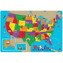
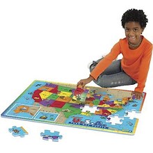
Educational Insights Foam Map Puzzles, USA
Item #: 901-JV37188
Age group and grade: Ages 5 - 7 and grades kindergarten+
Theme/design: Map
Material: Beech wood

Hygienist Laser Postcards, Time for Exam
Item #: 901-413860
Occasion: Reminder
MAP® Brand Hygienist Laser Postcards Time for Examcome in packs of 100 postacrds for easy mailing. Available in a variety of colors and patterns for use on laser printers. Laser postcards let you personalize each message for convenience.
Laser postcard sheets give you four full-color designs on every 8-1/2x11" laser postcard sheet


National Geographic Night Sky, Stargazer folded Map Pack Bundle, Folded: 4.25" x 9.25" ; Flat: 25.25" x 18.5" (NGMRE01021310B)
Item #: 901-24611374
National Geographic's The Night Sky - Stargazer Map Pack the Northern Hemisphere is centered on Polaris, the North Star, the Southern Hemisphere is centered near Crux, the Southern Cross.
Measures 4.25" x 9.25" folded and 25.25" x 18.5" flat
As the Earth moves in its orbit around the Sun the constellations in the sky change. The Night Sky maps include four seasonal charts that are specific for each season.

National Geographic Antarctica Satellite Map, Laminated, 31.25" x 20.25" (NGMRE00620144)
Item #: 901-24611405
National Geographic Antarctica Satellite Wall Map has a striking view of Antarctica's terrain, compiled from 4,500 satellite scans
Additional inset maps show surface elevation, ice sheet thickness, velocity of ice flow, and sea ice movement and windflow.
The map is encapsulated in heavy-duty 1.6 mil laminate which makes the paper much more durable and resistant to the swelling and shrinking caused by changes in humidity.
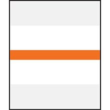
Medical Arts Press® Write-On or Type-On Divider Tabs; Orange
Item #: 901-30259MAP
Room to write on both sides
White plastic laminate with Orange coding stripe
Use with Chart Divider sheets or Fileback Dividers
$7.09
1-7 pack
($0.14/EACH)
Save 8%
$6.49
8+ pack
($0.13/EACH)

Medical Arts Press® Mini Color-Coding Labels; Yellow
Item #: 901-32679MAP
Affix these pressure-sensitive mini labels and organize charts by doctor, insurance type, or patient condition
Scored for wraparound color
250 Yellow labels per package
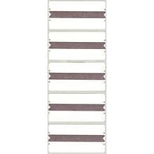
Medical Arts Press Wraparound Name Labels, Gray, 250/Pack (32606)
Item #: 901-32606MAP
Each label measures 1-5/8"H x 3-1/4"W
Format: sheet
Two name labels in one
$17.99
1-4 pack
($0.07/EACH)
Save 13%
$15.59
5+ pack
($0.06/EACH)


National Geographic Road Atlas 2024: Adventure Edition, United States, Canada, Mexico, 11" x 15" (NGMRD00620166)
Item #: 901-24611369
National Geographic's Road Atlas: Adventure Edition, is the ideal companion for the next time you hit the road.
Setting this atlas apart from all other road atlases are the inclusion of detailed maps and guidebook-like recommendations on the top 100 destinations for adventure.
Includes up-to-date road maps for all 50 U.S. States, plus Canada, Mexico, and Puerto Rico. Major cities and metropolitan areas are shown in detail with inset maps that include popular attractions.


National Geographic Earth's Moon Map, Laminated, 42.5" x 28.5" (NGMRE00620137)
Item #: 901-24611437
National Geographic's "The Earth's Moon" is like having an atlas and almanac in one.
This incredibly informative wall map features detailed depictions of the entire surface of the moon with a selective index showing the named physical features.
Diagrams show the moon's orbital paths, rotation around Earth, librations, how solar and lunar eclipses occur, how the moon affects Earth's tides, and more.


National Geographic Continental Divide Trail Map, In Gift Box, 18" x 48" (NGMRE01021204X)
Item #: 901-24611457
National Geographic Continental Divide Trail Wall Map- National Geographic's map of the Continental Divide Trail is ideal for fans and hikers of this magnificent National Scenic Trail.
Measures 18" x 48"
It makes a great planning tool or as reference to track progress on the 3,100 plus mile length.
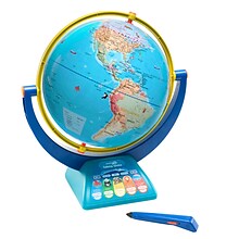

Educational Insights GeoSafari Jr. Talking Globe
Item #: 901-24366639
Travel the globe and discover the fascinating world of geography, animals, and nature
12” Globe featuring dual-swivel action and smart stylus pen with built-in speaker
Over 1,000 facts about animals and nature, countries and cities, continents and oceans
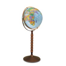
Replogle Globes Treasury Floor Model Globe, 12" (RE-30803)
Item #: 901-JV62863
Classroom World Globe
Size(s): 12" diameter
Material(s): Plastic, Wood, Metal


National Geographic Destination Mars: 2-Sided Map, Laminated, 31.25" x 20.25" (NGMRE00620141)
Item #: 901-24611411
Destination Mars was created for National Geographic with over 1,000 images taken by the Mars Orbiter Camera, and merged with 330 million elevation points to create the sharpest view yet of Mars.
See Mars as it really looks, from the heights of Olympus Mons, to Hellas Planitia, the lowest point on Mars, where a meteorite punched a hole in the surface 1,300 miles wide and five miles deep.
Measures 31.25" x 20.25"


National Geographic National Parks of the United States Map, Laminated, 42" x 30" (NGMRE01020602)
Item #: 901-24611394
Expertly researched and designed, National Geographic's wall map of National Parks of the United States highlights the nearly 400 magnificent parks across America.
Measures 42" x 30"
The country is represented in subtle earth-tones with shaded mountain relief and intricately drawn river systems.


National Geographic Appalachian Trail Map, In Gift Box, 18" x 48" (NGMRE01020716X)
Item #: 901-24611439
Expertly researched and designed, National Geographic's map of the Appalachian Trail is ideal for fans and hikers of this magnificent national scenic trail.
Measures 18" x 48"
It makes a great planning tool or as reference to track progress on the 2,200 mile length.

Teacher Created Resources Map Charts Set 9 Charts, 22" x 17" (TCR9689)
Item #: 901-JV24063211
Map Charts
22" x 17"
5+

National Geographic Australia Classic Map, Laminated, 30.25" x 27" (NGMRE00620146)
Item #: 901-24611407
Expertly researched and designed, National Geographic's Australia Wall Map is the authoritative map of Asia by which other reference maps are measured.
Signature Classic style map with bright, easy to read color palette with blue oceans and colorful borders
Clearly defined international boundaries, cities, islands, airports, and physical features
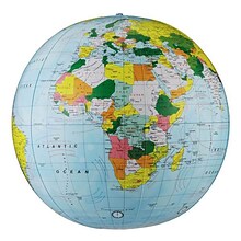
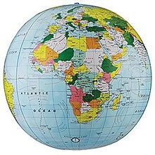
Replogle Globe Political Inflate-A-Globe, Light Blue, 16", 2/Bundle
Item #: 901-880408
Style: Political
Size: 16"(Dia)
Introduce children to geography with this inflatable globe, available in a variety of sizes and styles, each globe is brilliantly colored and extremely durable


National Geographic Continental Divide Trail Map, Laminated, 18" x 48" (NGMRE01021203)
Item #: 901-24611371
National Geographic Continental Divide Trail Wall Map- National Geographic's map of the Continental Divide Trail is ideal for fans and hikers of this magnificent National Scenic Trail.
Measures 18" x 48"
It makes a great planning tool or as reference to track progress on the 3,100 plus mile length.


