
Page 7 of world u s universal maps
(444 items found)
Sort by:
Best match
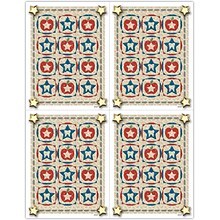
Dental Laser Postcards; American Star Quilt
Item #: 901-30327M
MAP® Brand Graphic Image Laser Postcards Star Quiltcome in packs of 100 postacrds for easy mailing. Available in a variety of colors and patterns for use on laser printers. Laser postcards let you personalize each message for convenience.
Laser postcard sheets give you four full-color designs on every 8-1/2x11" laser postcard sheet
Printed on high-grade coated stock for more vibrant color
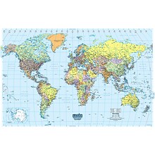
House of Doolittle Laminated World Map, 38" x 25" (HOD711)
Item #: 901-JV158531
Classroom World and U.S.A Map
Size: 25"(H) x 38"(W)
Material(s): Recycled Paper/Polyethylene


National Geographic United States Decorator Map, Laminated, 43.5" x 30.5" (NGMRE00622083)
Item #: 901-24611382
National Geographic's Decorator style map of the United States features rich, attractive color fills that bring any room or classroom to life.
Measures 43.5" x 30.5"
Colorful Decorator style map with vibrant color palette that fills each country for easy identification
Pacon® Corporation® Learning Walls® World Map (PAC78770)
Item #: 901-JV38298
Subject: Science/technology, nonfiction
Dimensions: 48" x 72"
A place for students and teachers to interact creatively


National Geographic Space, Stargazer folded Map Pack Bundle, Folded: 4.25" x 9.25" ; Flat: 25.25" x 18.5" (NGMRE01021309B)
Item #: 901-24611454
National Geographic's Stargazer Map and Guides Map Pack Bundle of Space includes maps that get progressively further from Earth on four waterproof tear-resistant maps.
Measures 4.25" x 9.25" folded and 25.25" x 18.5" flat
Each Stargazer Map and Guide shows detailed maps and graphics to help locate features on the moon, planets, and stars.


National Geographic Pacific Crest Trail Map, In Gift Box, 18" x 48" (NGMRE01020758X)
Item #: 901-24611433
Expertly researched and designed, National Geographic's map of the Pacific Crest Trail is ideal for fans and hikers of this magnificent National Scenic Trail.
Measures 18" x 48"
It makes a great planning tool or as reference to track progress on the 2,600 plus mile length.
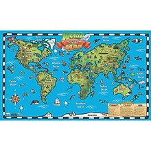
Popar 32" x 54" Kid's World Map Interactive Wall Chart with Free App (RWPWC04)
Item #: 901-24526317
Read-alongs and videos about the ancient world, modern world, and natural wonders
Measures 32" x 54"
Interactive with free app

Teacher Created Resources Map Charts Set 9 Charts, 22" x 17" (TCR9689)
Item #: 901-JV24063211
Map Charts
22" x 17"
5+
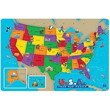
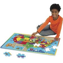
Educational Insights Foam Map Puzzles, USA
Item #: 901-JV37188
Age group and grade: Ages 5 - 7 and grades kindergarten+
Theme/design: Map
Material: Beech wood


National Geographic United States Classic Map, Poster Size and Laminated, 36" x 24" (NGMRE01020385)
Item #: 901-24611423
National Geographic United States Wall Map is expertly researched and designed, National Geographic's United States wall map is the standard by which other reference maps of the U.S. are measured.
The 36" x 24" poster size supports easy and affordable framing and mounting, and takes less wall space than standard wall maps.
Antique-style "executive" color palette
Ashley Productions Smart Poly 12" x 17" World Basic Map Learning Mat, Double-Sided (ASH95002)
Item #: 901-24529536
Heavy duty double-sided surface, no lamination required
Use with dry erase or water based markers and washable crayons
Water Resistant


National Geographic United States Executive Map, Poster Size and Laminated, 36" x 24" (NGMRE01020388)
Item #: 901-24611390
National Geographic's United States wall map is the standard by which other reference maps of the U.S. are measured.
The 36" x 24" poster size supports easy and affordable framing and mounting, and takes less wall space than standard wall maps.
Antique-style "executive" color palette


National Geographic Destination Mars: 2-Sided Map, Laminated, 31.25" x 20.25" (NGMRE00620141)
Item #: 901-24611411
Destination Mars was created for National Geographic with over 1,000 images taken by the Mars Orbiter Camera, and merged with 330 million elevation points to create the sharpest view yet of Mars.
See Mars as it really looks, from the heights of Olympus Mons, to Hellas Planitia, the lowest point on Mars, where a meteorite punched a hole in the surface 1,300 miles wide and five miles deep.
Measures 31.25" x 20.25"


National Geographic The Milky Way Map, Laminated, 31.25" x 20.25" (NGMRE00620140)
Item #: 901-24611410
This computer-generated image of the Milky Way shows the entire galaxy in one perspective of a 3-D model compiled specially for National Geographic.
The model incorporates the positions of hundreds of thousands of stars and nebulae within the galaxy, shows Earth's location.
Includes additional photographs, descriptions and locations of fascinating phenomena throughout the Milky Way.


National Geographic The Americas Classic Map, Laminated (NGMRE00620152)
Item #: 901-24611431
Expertly researched and designed, National Geographic's The Americas Wall Map is the authoritative map of Europe by which other reference maps are measured.
Measures 23.75" x 36.5"
Signature Classic style map with bright, easy to read color palette with blue oceans and colorful borders

National Geographic Australia Classic Map, Laminated, 30.25" x 27" (NGMRE00620146)
Item #: 901-24611407
Expertly researched and designed, National Geographic's Australia Wall Map is the authoritative map of Asia by which other reference maps are measured.
Signature Classic style map with bright, easy to read color palette with blue oceans and colorful borders
Clearly defined international boundaries, cities, islands, airports, and physical features

National Geographic Antarctica Satellite Map, Laminated, 31.25" x 20.25" (NGMRE00620144)
Item #: 901-24611405
National Geographic Antarctica Satellite Wall Map has a striking view of Antarctica's terrain, compiled from 4,500 satellite scans
Additional inset maps show surface elevation, ice sheet thickness, velocity of ice flow, and sea ice movement and windflow.
The map is encapsulated in heavy-duty 1.6 mil laminate which makes the paper much more durable and resistant to the swelling and shrinking caused by changes in humidity.


National Geographic Night Sky, Stargazer folded Map Pack Bundle, Folded: 4.25" x 9.25" ; Flat: 25.25" x 18.5" (NGMRE01021310B)
Item #: 901-24611374
National Geographic's The Night Sky - Stargazer Map Pack the Northern Hemisphere is centered on Polaris, the North Star, the Southern Hemisphere is centered near Crux, the Southern Cross.
Measures 4.25" x 9.25" folded and 25.25" x 18.5" flat
As the Earth moves in its orbit around the Sun the constellations in the sky change. The Night Sky maps include four seasonal charts that are specific for each season.
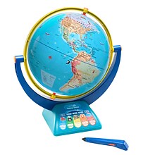

Educational Insights GeoSafari Jr. Talking Globe
Item #: 901-24366639
Travel the globe and discover the fascinating world of geography, animals, and nature
12” Globe featuring dual-swivel action and smart stylus pen with built-in speaker
Over 1,000 facts about animals and nature, countries and cities, continents and oceans
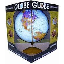
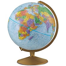
Replogle Globes The Explorer Globe, 12" (REP30519)
Item #: 901-JV23999851
Classroom World Globe
Size(s): 12" diameter
Material(s): Plastic

Medical Arts Press® Washington Tamper Resistant Prescription Pads; Standard 2-Part
Item #: 901-26532
Washington mandates that prescriptions are written on forms that meet tamper-resistant requirements and include the seal of approval
State map is heat sensitive to friction or heat, turning from green to yellow
"Dispense as written" and "Substitution permitted" signature lines


National Geographic United States Decorator Map, Enlarged and Laminated, 43.5" x 30.5" (NGMRE00622084)
Item #: 901-24611365
National Geographic's Decorator style map of the United States features rich, attractive color fills that bring any room or classroom to life.
Measures 43.5" x 30.5"
Colorful Decorator style map with vibrant color palette that fills each country for easy identification


National Geographic Continental Divide Trail Map, In Gift Box, 18" x 48" (NGMRE01021204X)
Item #: 901-24611457
National Geographic Continental Divide Trail Wall Map- National Geographic's map of the Continental Divide Trail is ideal for fans and hikers of this magnificent National Scenic Trail.
Measures 18" x 48"
It makes a great planning tool or as reference to track progress on the 3,100 plus mile length.


National Geographic Continental Divide Trail Map, Laminated, 18" x 48" (NGMRE01021203)
Item #: 901-24611371
National Geographic Continental Divide Trail Wall Map- National Geographic's map of the Continental Divide Trail is ideal for fans and hikers of this magnificent National Scenic Trail.
Measures 18" x 48"
It makes a great planning tool or as reference to track progress on the 3,100 plus mile length.


