
Page 2 of school globes
(124 items found)
Sort by:
Best match


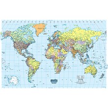
National Geographic World and United States for Kids, Poster Size, Map Pack Bundle, 36" x 24" (NGMRE01021233B)
Item #: 901-24611447
National Geographic's The World for Kids and United State for Kids wall maps are enticing and engaging world and United States maps perfect for classroom, home or library.
Measures 36" x 24"
Recommended by geography educators for ages 7–12, these maps feature an optimized map design for readability and easy, intuitive learning.


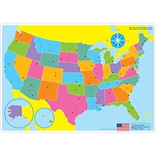
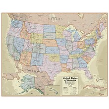
National Geographic United States Classic Map, Laminated, 43.5" x 30.5" (NGMRE00620411)
Item #: 901-24611428
National Geographic's United States wall map is the standard by which other reference maps of the U.S. are measured
Measures 43.5" x 30.5"
Signature Classic styling with bright, easy to read color palette with blue water and colorful state borders. All 50 states with insets for Hawaiian Islands and Alaska


National Geographic The Dynamic Earth, Plate Tectonics Map, Laminated, 36" x 24" (NGMRE01020634)
Item #: 901-24611386
National Geographic Dynamic Earth, Plate Tectonics Wall Map illustrates plate tectonics & features stunning bathymetry & naturally colored relief, as well as volcano and earthquake data through 2011.
Measures 36" x 24"
The Dynamic Earth map illustrates 17 major tectonic plates and highlights diffuse plate boundaries, convergent boundaries, spreading boundaries, fault zones, hot spots, and more.

House of Doolittle Laminated World Map, 50" x 33" (HOD710)
Item #: 901-JV158533
Laminated Classroom World Map
Size: 33"(H) x 50"(W)
Material(s): Recycled Paper/Polyethylene


National Geographic United States Executive Map, Enlarged and Laminated, 69.25" x 48" (NGMRE00620117)
Item #: 901-24611419
National Geographic United States Wall Map is expertly researched and designed, National Geographic's United States wall map is the standard by which other reference maps of the U.S. are measured.
Antique-style "executive" color palette
Enlarged maps provide an immersive experience in any home or office environment. The exceptional cartography is even easier to appreciate at the larger size


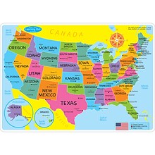
National Geographic United States for Kids Map, Laminated, 24" x 36" (NGMRE01021159)
Item #: 901-24611434
Expertly researched and designed, National Geographic's The United States for Kids wall map is an enticing and engaging United States map perfect for classroom, home or library.
Measures 24" x 36"
Recommended by geography educators for ages 7–12, this map features an optimized map design for readability and easy, intuitive learning.

Teacher Created Resources® Travel the Map Future World Changers Bulletin Board Set (TCR8623)
Item #: 901-24509404
Vintage-looking accents and inspiring messages will encourage them to explore, dream, and discover new worlds
Globe measures about 14" x 19-1/2"
48 total pieces


National Geographic World Physical Map, Enlarged and Laminated, 69.25" x 46.25" (NGMRE00620133)
Item #: 901-24611445
Expertly researched and designed, National Geographic's The Physical World map highlights the Earth's land and undersea forms with exquisite hand-painted relief.
Two corner inset maps show the Earth's crust and world climatic zones.
Enlarged maps provide an immersive experience in any home or office environment. The exceptional cartography is even easier to appreciate at the larger size


National Geographic The World for Kids Map, Laminated, 36" x 24" (NGMRE01020772)
Item #: 901-24611323
Expertly researched and designed, National Geographic's The World for Kids wall map is an enticing and engaging world map perfect for classroom, home or library.
Measures 36" x 24"
Recommended by geography educators for ages 7–12, this map features an optimized map design for readability and easy, intuitive learning.
Ashley Productions Smart Poly™ Learning Mats, 12" x 17", Double-Sided, U.S. Basic Map, Pack of 10 (ASH95600)
Item #: 901-24389608
Water Resistant
Colorful designs on both sides
Measures 12" x 17", pack of 10 learning mats


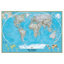
National Geographic World Classic Map, Laminated, 43.5" x 30.5" (NGMRE00622002)
Item #: 901-24611430
Expertly researched and designed, National Geographic's World Wall Map is the authoritative map of the world by which other reference maps are measured.
Measures 43.5" x 30.5"
Signature Classic style map with bright, easy to read color palette with blue oceans and colorful borders
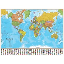
Hemispheres® Boardroom Series World Laminated Wall Map, 38" x 61" (RWPHM03)
Item #: 901-24519762
Modern antique decorative style
Up-to-date cartography and points of interest
Includes countries, capitals, major cities and more

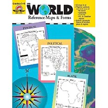
Evan-Moor® The World - Reference Maps & Forms
Item #: 901-JV37097
Age group and grade: Ages 3 - 18 and grades 3rd - 6th
Also includes evaluation forms, crossword puzzle, word search and answer key
Author: Jo Ellen Moore
Hemispheres® Boardroom Series United States Laminated Wall Map, 38" x 48" (RWPHM04)
Item #: 901-24519761
Modern antique decorative style
Up-to-date cartography and points of interest
Includes states, capitals and more
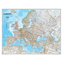
National Geographic Maps Europe Wall Map, 30" x 24"
Item #: 901-JV158525
Subject: Social studies
Subject: Science/technology, nonfiction
Dimensions: 30" x 24"


National Geographic Road Atlas 2024: Adventure Edition, United States, Canada, Mexico, 11" x 15" (NGMRD00620166)
Item #: 901-24611369
National Geographic's Road Atlas: Adventure Edition, is the ideal companion for the next time you hit the road.
Setting this atlas apart from all other road atlases are the inclusion of detailed maps and guidebook-like recommendations on the top 100 destinations for adventure.
Includes up-to-date road maps for all 50 U.S. States, plus Canada, Mexico, and Puerto Rico. Major cities and metropolitan areas are shown in detail with inset maps that include popular attractions.
Hemispheres Blue Ocean Series World & USA Laminated Wall Maps, 2-Pack (RWPHMB02PK)
Item #: 901-JV1112500
Classroom U.S.A & World Map
Size(s): 38" x 51" World, 38" x 48" USA
Material(s): Laminated Paper
Ghent® Maprail Flag Holder, 1", 2 EA/BD
Item #: 901-877757
Add lots of capability to the rail
Grades: All
Age: All


National Geographic World Executive Map, Laminated, 46" x 30.5" (NGMRE00622087)
Item #: 901-24611366
Expertly researched and designed, National Geographic's World Wall Map is the authoritative map of the world by which other reference maps are measured.
Measures 46" x 30.5"
Antique-style "executive" color palette


National Geographic Pacific Crest Trail Map, In Gift Box, 18" x 48" (NGMRE01020758X)
Item #: 901-24611433
Expertly researched and designed, National Geographic's map of the Pacific Crest Trail is ideal for fans and hikers of this magnificent National Scenic Trail.
Measures 18" x 48"
It makes a great planning tool or as reference to track progress on the 2,600 plus mile length.
House of Doolittle Laminated World Map, 38" x 25" (HOD711)
Item #: 901-JV158531
Classroom World and U.S.A Map
Size: 25"(H) x 38"(W)
Material(s): Recycled Paper/Polyethylene
National Geographic World Classic Wall Map, Mural, 110" x 76.5" (NGMRE00622007)
Item #: 901-JV62402
Mural World Map
Size(s): 110" x 76.5"
Material(s): Laminated Paper


Waypoint Geographic World/USA Laminated Notebook Maps, 32/Pack (RWPNB03)
Item #: 901-24610195
Makes easy reference for continents, countries, states and major World and USA cities and other points of interest. Laminated
World on one side, USA on the other
Set includes 32 notebook maps measuring 8.5" x 11"


National Geographic United States Decorator Map, Enlarged and Laminated, 43.5" x 30.5" (NGMRE00622084)
Item #: 901-24611365
National Geographic's Decorator style map of the United States features rich, attractive color fills that bring any room or classroom to life.
Measures 43.5" x 30.5"
Colorful Decorator style map with vibrant color palette that fills each country for easy identification


