Page 3 of school globes
(124 items found)
Sort by:
Best match


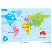
National Geographic World Classic Map, Enlarged and Laminated, 69.25" x 48" (NGMRE00622003)
Item #: 901-24611409
Expertly researched and designed, National Geographic's World Wall Map is the authoritative map of the world by which other reference maps are measured.
Measures 69.25" x 48"
Signature Classic style map with bright, easy to read color palette with blue oceans and colorful borders


National Geographic United States Classic Map, Enlarged and Laminated, 69.25" x 48" (NGMRE00602987)
Item #: 901-24611392
National Geographic's United States wall map is the standard by which other reference maps of the U.S. are measured
Signature Classic styling with bright, easy to read color palette with blue water and colorful state borders. All 50 states with insets for Hawaiian Islands and Alaska
Enlarged maps provide an immersive experience in any home or office environment. The exceptional cartography is even easier to appreciate at the larger size


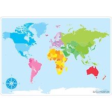
National Geographic World Decorator Map, Enlarged and Laminated, 73" x 48" (NGMRE00622080)
Item #: 901-24611320
Expertly researched and designed, National Geographic's World Wall Map is the authoritative map of the world by which other reference maps are measured.
Measures 73" x 48"
Colorful Decorator style map with vibrant color palette that fills each country for easy identification
Ashley Productions Smart Poly™ Learning Mats, 12" x 17", Double-Sided, World Basic Map, Pack of 10 (ASH95602)
Item #: 901-24389567
Water Resistant
Colorful designs on both sides
Measures 12" x 17", pack of 10 learning mats
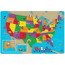
Educational Insights Foam Map Puzzles, USA
Item #: 901-JV37188
Age group and grade: Ages 5 - 7 and grades kindergarten+
Theme/design: Map
Material: Beech wood


National Geographic United States Decorator Map, Laminated, 43.5" x 30.5" (NGMRE00622083)
Item #: 901-24611382
National Geographic's Decorator style map of the United States features rich, attractive color fills that bring any room or classroom to life.
Measures 43.5" x 30.5"
Colorful Decorator style map with vibrant color palette that fills each country for easy identification


National Geographic World Executive Map, Poster Size and Laminated, 36" x 24" (NGMRE01020376)
Item #: 901-24611378
Expertly researched and designed, National Geographic's World Wall Map is the authoritative map of the world by which other reference maps are measured.
The 36" x 24" poster size supports easy and affordable framing and mounting, and takes less wall space than standard wall maps.
Antique-style "executive" color palette


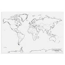
National Geographic World and United States Coloring, Map Pack Bundle, 36" x 24" (NGMRE01021221B)
Item #: 901-24611425
National Geographic's cartographers adapted our World and United States for Kids Maps to black and white outline versions that you can color.
Measures 36" x 24"
The World and United States Coloring Maps include country and state flags that can all be colored along with a bonus full color letter size sheets that has all of the flags.


National Geographic The Heavens Map, Laminated, 30.5" x 22.75" (NGMRE00620136)
Item #: 901-24611415
National Geographic's The Heavens shows star charts and constellations for both the Northern and Southern Hemispheres.
All 2,844 of the stars on the chart, plus nebulae and star clusters, can be seen with the unaided eye, making this chart a perfect companion for viewing the night sky.
They inspire great works of art, and tempt our imaginations into creating stories and myths from the shapes we see.


National Geographic The Milky Way Map, Laminated, 31.25" x 20.25" (NGMRE00620140)
Item #: 901-24611410
This computer-generated image of the Milky Way shows the entire galaxy in one perspective of a 3-D model compiled specially for National Geographic.
The model incorporates the positions of hundreds of thousands of stars and nebulae within the galaxy, shows Earth's location.
Includes additional photographs, descriptions and locations of fascinating phenomena throughout the Milky Way.


National Geographic Pacific Crest Trail Map, Laminated, 18" x 48" (NGMRE01020759)
Item #: 901-24611417
Expertly researched and designed, National Geographic's map of the Pacific Crest Trail is ideal for fans and hikers of this magnificent National Scenic Trail.
Measures 18" x 48"
It makes a great planning tool or as reference to track progress on the 2,600 plus mile length.


National Geographic World Executive Map, Mural, 110" x 76.5" (NGMRE00620092)
Item #: 901-24611398
National Geographic World Wall Map Executive is expertly researched and designed, National Geographic's World Wall Map is the authoritative map of the world by which other reference maps are measured.
Antique-style "executive" color palette
Thousands of place names carefully and artfully placed to maintain legibility in heavily populated areas


Waypoint Geographic World/USA Laminated Notebook Maps, 12/Pack (RWPNB02)
Item #: 901-24610186
Makes easy reference for continents, countries, states and major World and USA cities and other points of interest. Laminated
World on one side, USA on the other
Set includes 12 notebook maps measuring 8.5" x 11" and a 12 count clip strip
Pacon® Corporation® Learning Walls® World Map (PAC78770)
Item #: 901-JV38298
Subject: Science/technology, nonfiction
Dimensions: 48" x 72"
A place for students and teachers to interact creatively
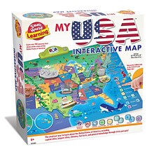
Small World Toys My USA Interactive Map, 30.7" x 24" (SWT9721053)
Item #: 901-24519539
Great learning and educational toy
Interactive talking map
Great way for children to learn the USA map while playing


National Geographic World Executive Map, Enlarged and Laminated, 73" x 48" (NGMRE00622088)
Item #: 901-24611311
Expertly researched and designed, National Geographic's World Wall Map is the authoritative map of the world by which other reference maps are measured.
Measures 73" x 48"
Antique-style "executive" color palette

Teacher Created Resources Map Charts Set 9 Charts, 22" x 17" (TCR9689)
Item #: 901-JV24063211
Map Charts
22" x 17"
5+


National Geographic World Physical Map, Laminated, 45.75" x 30.5" (NGMRE00620132)
Item #: 901-24611413
Expertly researched and designed, National Geographic's The Physical World map highlights the Earth's land and undersea forms with exquisite hand-painted relief.
Two corner inset maps show the Earth's crust and world climatic zones.
Drawn in the Winkel Tripel projection, distortions are minimized and unlike many other World maps, Greenland is show the same size as Argentina and not as the size of all of South America.


National Geographic United States Classic Map, Poster Size and Laminated, 36" x 24" (NGMRE01020385)
Item #: 901-24611423
National Geographic United States Wall Map is expertly researched and designed, National Geographic's United States wall map is the standard by which other reference maps of the U.S. are measured.
The 36" x 24" poster size supports easy and affordable framing and mounting, and takes less wall space than standard wall maps.
Antique-style "executive" color palette


National Geographic Space, Stargazer folded Map Pack Bundle, Folded: 4.25" x 9.25" ; Flat: 25.25" x 18.5" (NGMRE01021309B)
Item #: 901-24611454
National Geographic's Stargazer Map and Guides Map Pack Bundle of Space includes maps that get progressively further from Earth on four waterproof tear-resistant maps.
Measures 4.25" x 9.25" folded and 25.25" x 18.5" flat
Each Stargazer Map and Guide shows detailed maps and graphics to help locate features on the moon, planets, and stars.


National Geographic World and United States Executive, Poster Size, Map Pack Bundle, 36" x 24" (NGMRE01021232B)
Item #: 901-24611443
National Geographic's World and United States maps are the standard by which all other reference maps are measured.
Measures 36" x 24"
Antique-style "executive" color palette
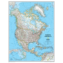
National Geographic Maps North America Wall Map, 24" x 30"
Item #: 901-JV158524
Subject: Social studies
Subject: Science/technology, nonfiction
Dimensions: 24" x 30"


National Geographic The Universe Map, Laminated, 31.25" x 20.25" (NGMRE00620139)
Item #: 901-24611384
National Geographic's Universe Wall Map, shows as far as we can see with our ever-improving telescope, at least a hundred billion galaxies arrayed throughout the universe.
This map uses graphic leaps of scales to show how our solar system fits within the vastness of the universe.
The map also includes a universe timeline and a description of its evolution.
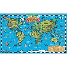
Popar 32" x 54" Kid's World Map Interactive Wall Chart with Free App (RWPWC04)
Item #: 901-24526317
Read-alongs and videos about the ancient world, modern world, and natural wonders
Measures 32" x 54"
Interactive with free app


